RIGHT!
The last thing we need to cover with this lesson is a few geographic terms,
starting with WATER RIGHTS. Water
Rights are the right to use water on, or adjacent to a property. There are several types of water
rights. RIPARIAN rights are the rights
along a river or stream. Under Riparian
rights, the owner of an adjacent property owns to the center of the river or
stream if it is NOT navigable (meaning no boats or ships can sail or navigate
through the water). If the river IS
navigable, then the property owner owns to the water’s edge, and the government
owns the river itself. Riparian can be
remembered by thinking that Riparian and River both begin with the
letter “R.”
LITTORAL rights are along a lake or larger body of
water (Atlantic Ocean, Gulf of Mexico, Chesapeake Bay, etc.). Under Littoral rights, the property owner
owns to the mean high water mark (the point exactly in the middle of the
highest high water mark and the lowest high water mark, i.e. the normal high
tide). The government owns beyond that
point. Littoral can be remembered,
because Littoral, Lake and Larger Body of Water all begin
with the letter “L.” Under both
Littoral and Riparian rights, the government may give a property owner the
right to build a private pier that extends out into the body of water.
One other term associated with water rights is the
doctrine of PRIOR APPROPRIATION. This
is used in states where water is scarce.
Under Prior Appropriation, the state owns the water rights except for
limited domestic use.
Aside from water rights, there are a few other geographic terms you may need
to know. AVULSION is the sudden loss of
land by an act of nature. If a flash
flood washes part of your property away, that is Avulsion. The process where land is gained by deposits
from a river, lake or stream is called ACCRETION, and the actual soil deposited
is called ALLUVIUM (or ALLUVIAL DEPOSITS).
The gradual wearing away of land by wind, rain or water is called
EROSION. And the process where land is
gained by water receding is called RELICTION.
To determine the geographic features of a property,
someone might use a CONTOUR MAP. This
can be used to show elevations and the layout of the land, for example, where
hills and other features are located, and how steep or gradual the hills
are. This is done on a Contour Map by
drawing lines between points of equal elevation, so that every point on any
line will be at the same level.
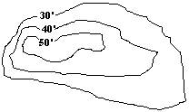
In the Contour Map above, the slope on the left side is
steeper, because you don’t have to travel very far to drop down 10 feet, but on
the right is a more gradual slope, because you have to travel a longer distance
to drop 10 feet.
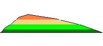
A TOPOGRAPHIC MAP serves the same basic function, but
may use colors or a cut away view to show the elevations.

Now
that you know all the fundamentals of property, let’s take a QUIZ! Click here!
If you have any questions you can e-mail me at HELP@yourdailyquiz.com